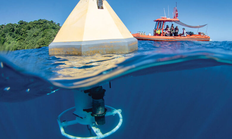
Kiribati’s plans for an improved pier on Kanton Island were at a standstill. Australia had committed to completing the project, but outdated information about the underwater topography surrounding the remote atoll had stymied the delivery of materials for planned upgrades. Crews needed underwater terrain mapping and information about ocean depth before it was safe for mariners to bring in supplies, said Capt. Daniel Simon, a former National Oceanic and Atmospheric Administration (NOAA), liaison to the U.S. Indo-Pacific Command. “It was going to be another year or two before they got a survey done,” he added.
Enter NOAA Ship Rainier, which was deployed in the region to image and map the seafloor, assess coral reef health, and gather data on marine wildlife. At the request of Kiribati’s Ministry of Information, Communication and Transport, the Rainier conducted an underwater survey around Kanton Island, using a multibeam sonar system to produce a high-resolution map of the seafloor and its features. It was the first survey of the island since the 1950s, Simon said. The results, shared with Kiribati, will update nautical charts and contribute to resource management, according to NOAA.
The agency’s partnership is providing valuable insights as Kiribati works to improve underwater mapping and nautical charts around its 33 atolls, which are spread over nearly 3.5 million square kilometers. Such underwater intelligence improves safety and navigation for island nations reliant on the ocean for transportation and trade, supports ecosystem monitoring and protection, and promotes sustainable growth.
The main obstacles to gaining a detailed picture of the surrounding sea have been cost and labor, Tion Uriam, Kiribati’s national coordinator for hydrography and charting, told the Netherlands-based Hydro International magazine. He also cited the need to raise awareness of how surveys such as the one completed by the Rainier can contribute to long-term economic planning. “The phrase ‘we cannot manage what we can’t measure’ is especially relevant in the context of Kiribati,” Uriam said. NOAA has helped reinforce the message with workshops for Kiribati government officials on managing data under a United Nations framework to help ensure global access.

Sharing versus hoarding data
Oceans cover about 70% of the Earth’s surface, influence climate and weather patterns, support marine species that feed billions of people, carry an estimated 90% of the world’s goods, and contribute to at least $2.5 trillion in global commerce annually. With the world’s seas imperiled by pollution, overfishing and other threats, real-time information is crucial for a baseline understanding of ocean health, insight into changing conditions, and measures to protect critical resources and enable sustainable development. NOAA is among the agencies continuously collecting ocean information from satellites, surface and underwater expeditions, buoys, uncrewed sensors, and other sources. Technology is advancing so rapidly that researchers can compile more information in a year than was gathered during the entire 20th century, according to research published in the journal Frontiers in Marine Science.
To produce results, however, data must be accessible, interoperable and reusable. NOAA, which generates massive volumes of data daily, uploads the information to the cloud through its Open Data Dissemination Program, making the environmental intelligence available to anyone with an internet connection. Programs such as NOAA’s National Centers for Environmental Information provide access to historical data. Simon cited the Rainier as an example: “When that ship leaves port and turns on those sensors, the information is getting input directly into the cloud and is readily available to the public instantaneously.”
The World Ocean Database, a NOAA-led project of the Intergovernmental Oceanographic Commission, is the largest unrestricted, uniformly formatted and quality-controlled database for ocean information. It represents over 20 years of effort to integrate research and includes data spanning 250 years. NOAA also shares satellite observations for meteorological and environmental forecasts on a full, free and open basis. Recognizing that no single entity can effectively monitor the world’s weather, climate, oceans and coastlines, the agency maintains partnerships with groups such as the European Organisation for the Exploitation of Meteorological Satellites and the Japan Meteorological Agency to loan and borrow satellites. Such agreements ensure the availability of data — for the U.S., for its Allies and Partners, and for all regions of the world — in case of technological failure. NOAA also is advancing cooperation with the Indian Space Research Organisation, the Vietnam National Space Center and other partners across the globe, according to its satellite service’s International and Interagency Affairs Division.
Dozens of nations conduct ocean research, contributing to a global understanding of the sea. China’s programs, which are among the world’s largest, stand out for their lack of transparency, however. Vessels often owned and operated by Chinese state- and military-affiliated organizations concentrate survey operations in the Western Pacific and the South China Sea. Beijing claims about 90% of the latter despite an international tribunal’s 2016 ruling that invalidated the territorial claim. China’s secrecy obscures the nature of its research, wrote analysts from the Center for Strategic and International Studies (CSIS), a Washington, D.C.-based think tank, in the January 2024 report “Surveying the Seas: China’s Dual-Use Research Operations in the Indian Ocean.”
They note that Chinese survey ships have falsified location information or turned off automatic identification systems, which broadcast a vessel’s identity and position to ensure maritime safety, for extended periods. Beijing’s ships have conducted illegal research, such as oil and gas surveys, in other countries’ exclusive economic zones, where those nations have sovereign rights and jurisdiction over marine resources. China also has used the vessels for intimidation to support illegal territorial claims, according to the CSIS report. Researchers have accused China of gathering valuable data from other countries without sharing the information among collaborating scientists, reported University World News, a higher education publication.
While the Chinese Communist Party (CCP) has a record of “voraciously acquiring” data across research spectrums, it is unwilling to share that information, Dr. Ethan Allen, an environmental science and climate security expert at the Daniel K. Inouye Asia-Pacific Center for Security Studies (DKI-APCSS) in Honolulu, Hawaii, told FORUM. Although recent collaborations on climate science are a hopeful sign, he said, “especially when compared to the relatively open U.S. and Western scientific process, the CCP appears to regard data as a resource to be hoarded rather than distributed.”

Mapping unknown depths
As seabed mapping creates economic opportunity for nations and improves navigation and safety for mariners, a better understanding of the seafloor also contributes to environmental protections and resource management, disaster preparedness, and climate mitigation.
Comprehensive maps identify and detail habitats that can support marine life, such as the underwater mountains, trenches and canyons NOAA has mapped across millions of square kilometers. Knowledge of the ocean’s depth can guide research in ocean acidification, the carbon-induced chemical change that threatens ecosystems. An accurate picture of the seafloor can identify earthquake-prone areas, where disruptions can spark tsunamis, for improved monitoring and advanced warning systems. The rugged seabed impacts ocean currents, which influence temperature and play a role in climate models. Research suggests that understanding the shape and depth of the seafloor can tell scientists more about the ocean’s ability to absorb carbon, which is also key to combating climate challenges.
The world’s oceans are inextricably linked to its fresh water, atmosphere, ice caps and more, which makes it important to fully understand the sea, Allen said. “But we are dealing with sort of a blank slate in terms of what exists in the abyssal [deepest] ocean,” he added. “There are thousands, probably tens of thousands, probably hundreds of thousands of life forms, species we know nothing about, that live in this environment. How these interact with other life forms in the ocean, how they serve as parts of the food chain, what their roles are — that’s very poorly understood.”
Just over 26% of the ocean floor has been mapped, according to Seabed 2030, an international organization aiming to produce a definitive map of the world’s oceans by the end of the decade — and making the information available to all. NOAA is among the dozens of partners supporting Seabed 2030, founded in 2017 by Japan’s The Nippon Foundation and the 120-year-old General Bathymetric Chart of the Oceans (GEBCO) project, by working to map all U.S. waters and to support compiling the data into the freely available GEBCO map.

‘Need for collaboration’
NOAA agencies also combat illegal, unreported and unregulated (IUU) fishing, which robs the global economy of tens of billions of dollars annually, threatens food security and harms ocean ecosystems. NOAA’s Office of Law Enforcement builds international capacity to combat IUU fishing, offering policy and framework assistance, and training partners such as Indonesia, the Philippines and Thailand on surveillance, data collection and measures to restrict port entry for vessels engaging in illicit activity.
Climate research depends on NOAA observations, such as sea levels, ocean temperature, ocean acidification and carbon emissions used to better predict the impact of a warming world. Meanwhile, the U.S. agency promotes marine protected areas, which contribute to climate resilience by storing carbon and preserve biodiversity by protecting resources such as coral reefs and fisheries. NOAA is spearheading efforts for a national marine sanctuary to expand protections for the Pacific Remote Islands Marine National Monument, southwest of Hawaii in the Central Pacific. “The atolls, shoals, banks, reefs, seamounts, and open-ocean waters surrounding the Pacific Remote Islands are home to some of the most diverse and remarkable tropical marine life on the planet but are becoming increasingly vulnerable to impacts from climate change, invasive species, and marine debris,” the agency stated. “The region’s diverse habitats and pristine reefs provide a haven for a variety of fish, invertebrates, seabirds, sea turtles, and marine mammals — many found nowhere else in the world.”
NOAA researchers also collaborate internationally on weather modeling and forecasting, such as with the Integrated Ocean Observing System in the Western Pacific. Programs to track, remove and mitigate marine debris — from plastic pollution to fishing gear — involve worldwide partners. Coral reef data supports conservation globally while NOAA partners with nations on tools and best practices to protect the ecosystems. Much of NOAA’s environmental intelligence is collected within U.S. waters, given the agency’s focus and its authorities. “But pollution, fish, storms? They don’t have geopolitical borders,” Simon said. “We have a lot of information, a lot of products, a lot of services that go well beyond our exclusive economic zones.”
For Allen, the DKI-APCSS professor, such interdependence illustrates a crucial point about scientific cooperation. “We live on a very small planet,” he said. “We’re all breathing the same air. We’re all drinking the same water. We’d better start collaborating on how to keep our air reasonably clean and our water drinkable. There’s really an unprecedented need for collaboration on a bigger, deeper, more global level than we’ve ever seen before.”